
The Bergen County section was part of the Bergen-Passaic Expressway, a road planned in the 1940s but not completed until the 1960s to alleviate congestion on US 1/9/46 and NJ 4 as approaches to the George Washington Bridge. Specifically, the Bergen-Passaic Expressway was designed to pull Paterson-bound traffic off NJ 4. When the road was added to the Interstate highway system, it became part of a greater conduit from the west; however, the last sections of I-80 west of Paterson were not completed until the 1970s.
Contrary to popular belief, I-80 does not go to New York, even though New York is given as a control city on eastbound signs throughout New Jersey and even near Youngstown, Ohio (but not, curiously, in Pennsylvania). Prior to the completion of I-95 in the Ridgefield Park area, the entire Bergen-Passaic Expressway was signed I-80; today, the road's eastern terminus is at the New Jersey Turnpike in Teaneck.
Only the 8.1-mile portion of the freeway in Bergen County is included here; the mile markers are from the highway's New Jersey origin at the Delaware River.
| Mile | Street Name | Feature (West to East) |
| 60.44 | Entering Elmwood Park Boro, Bergen Co. | |
| 60.44 | Bergen-Passaic Expwy | Passaic River {bridge} |
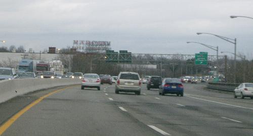 Crossing into Bergen County on eastbound I-80. The Marcal Paper Mills plant has been an I-80 landmark in Elmwood Park for decades. | ||
| 60.50 | Bergen-Passaic Expwy | Slaughterdam Rd {bridge} |
| 60.81 | Bergen-Passaic Expwy | River Dr, CR 507, Interchange 61 |
| 60.91 | Bergen-Passaic Expwy | Market St, CR 56 |
| 61.06 | Bergen-Passaic Expwy | S Center St {overpass} |
| 61.19 | Bergen-Passaic Expwy | Susquehanna Railroad {overpass} |
| 61.31 | Bergen-Passaic Expwy | Boulevard {overpass} |
| 61.43 | Bergen-Passaic Expwy | Branch Fleischer Brook {pipe} |
| 61.54 | Bergen-Passaic Expwy | Fleischer Brook {bridge} |
| 61.82 | Bergen-Passaic Expwy | Garden State Pkwy, NJ 444 {overpass} |
| 61.92 | Bergen-Passaic Expwy | Erie Railroad {overpass} |
| 61.92 | Entering Saddle Brook Twp | |
| 61.96 | Bergen-Passaic Expwy | Midland Ave, CR 67 {overpass} |
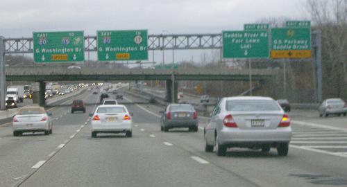 Decisions, decisions! Fortunately, the advisories start about a mile earlier. | ||
| 62.34 | Bergen-Passaic Expwy | Ramp to Garden State Pkwy, Interchange 62A {underpass} |
| 62.74 | Eastbound lanes split local/express | |
| 62.86 | Bergen-Passaic Expwy | Mayhill St {underpass} |
| 63.20 | Bergen-Passaic Expwy | Saddle River Rd, CR 79, Interchange 62B {overpass} |
| 63.23 | Bergen-Passaic Expwy | Susquehanna Railroad {overpass} |
| 63.64 | Bergen-Passaic Expwy | Market St, CR 56 {bridge} |
| 63.65 | Bergen-Passaic Expwy | Saddle River {bridge} |
| 63.65 | Entering Lodi Boro | |
| 63.70 | Bergen-Passaic Expwy | Main St, CR 61 {bridge} |
| 63.82 | Bergen-Passaic Expwy | Riverview Ave, Interchange 63B {underpass} |
| 64.09 | Bergen-Passaic Expwy | Unnamed stream {pipe} |
| 64.46 | Bergen-Passaic Expwy | Susquehanna Railroad spur {overpass} |
| 64.47 | Bergen-Passaic Expwy | NJ 17 {overpass} |
| 64.58 | Westbound lanes split local/express | |
| 64.77 | Entering Hackensack City | |
 Eastbound, just inside Hackensack. The first, slanting overpass is Summit Avenue; the second, visible beyond it, is northbound NJ 17. The big green signs visible on the far right are on southbound NJ 17. | ||
| 65.04 | Bergen-Passaic Expwy | Summit Ave, CR 57 {underpass} |
| 65.19 | Bergen-Passaic Expwy | NJ 17, Interchange 64A {underpass} |
| 65.40 | Bergen-Passaic Expwy | Polifly Rd, CR 55, Interchange 64B {overpass} |
| 65.65 | Bergen-Passaic Expwy | Erie Railroad {overpass} |
| 65.65 | Entering South Hackensack Twp | |
| 65.67 | Bergen-Passaic Expwy | Green St, Interchange 65 {underpass} |
| 65.81 | Entering Teterboro Boro | |
| 66.10 | Entering South Hackensack Twp | |
| 66.20 | Bergen-Passaic Expwy | Huyler St, CR S-40 {underpass} |
| 66.42 | Bergen-Passaic Expwy | Phillips St {underpass} |
| 66.50 | Entering Hackensack City | |
| 66.56 | Bergen-Passaic Expwy | Ramp from Kennedy St {underpass} |
| 66.70 | Bergen-Passaic Expwy | Hudson St, CR 124, Interchange 66 {underpass} |
| 66.81 | Bergen-Passaic Expwy | River St, CR 503 {bridge} |
| 66.97 | Bergen-Passaic Expwy | Hackensack River {bridge} |
| 66.97 | Entering Ridgefield Park Village | |
| 67.05 | Bergen-Passaic Expwy | Susquehanna Railroad {bridge} |
| 67.11 | Bergen-Passaic Expwy | West Shore Railroad {bridge} |
| 67.13 | Bergen-Passaic Expwy | Railroad Ave, CR 41 {bridge} |
| 67.22 | Bergen-Passaic Expwy | 2nd St, Interchange 67 {underpass} |
| 67.38 | Entering Bogota Boro | |
| 67.58 | Bergen-Passaic Expwy | Queen Anne Rd {underpass} |
| 67.58 | Entering Teaneck Twp | |
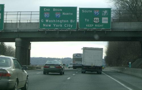 The end is near: I-80 terminates less than a mile from here. | ||
| 67.72 | Bergen-Passaic Expwy | Park Ave {underpass} |
| 67.97 | Bergen-Passaic Expwy | Teaneck Rd, CR 39 {underpass} |
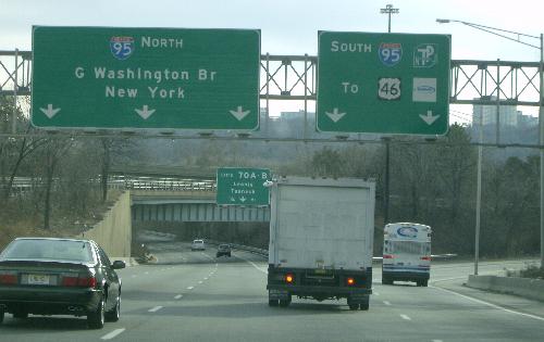 The last signs placed by NJDOT in the local lanes. The sign for Exit 70 (on I-95) was placed by the New Jersey Turnpike Authority, replacing an older NJDOT sign. | ||
| 68.13 | Bergen-Passaic Expwy | New Jersey Turnpike, I-95, Interchange 68 {underpass} |
| 68.54 | I-80 ENDS, Teaneck Twp | |
| 68.54 | Bergen-Passaic Expwy (I-95) now part of NJ Turnpike (1994) | |